66 1/2 BOND STREET, Denham Town, Kingston
Property information for 66 1/2 BOND STREET, KINGSTON, Denham Town, Kingston
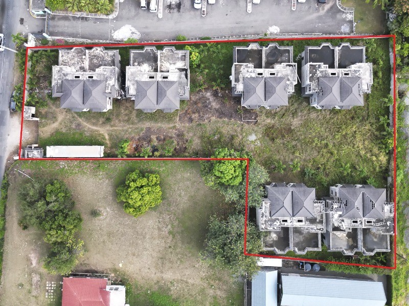
🗺️ Property Map
Interactive map showing the exact property boundaries and location
Loading map...
AI-powered estimation based on comprehensive analysis of location, demographics, infrastructure, and market factors
Estimated Value (JMD)
JMD 57,035,315
Estimated Value (USD)
USD 380,235
Confidence Score
75%
Market Multiplier
0.92x
📊 Value Range Analysis
JMD Range:
JMD 45,628,252 - JMD 68,442,378
JMD 45,628,252 - JMD 68,442,378
📊 Analysis Details
Summary: AI analysis indicates a land value of JMD 57,035,315 based on 75% confidence analysis of population density, building count, facilities, and environmental factors.
Key Factors: Population density: 4063 people • Building count: 0 • Nearby facilities: 0 • Environmental score: 0.0% • Economic score: 0.0%
Tax Status: Not Available
Legal: Property appears to be legally registered
Improvements: Vacant land with development potential
In and Around
Buildings, public facilities, attractions and transport identified at or near this parcel — sourced from OpenStreetMap and our analysis pipeline.
Public Facilities
5- Kingston Public HospitalNearby153 mHospital
- All Saints SchoolNearby316 mSchool
- North Street PrimaryNearby351 mSchool
- Denham Town High SchoolNearby351 mSchool
- Denham Town Primary SchoolNearby500 mSchool
Retail & Commercial
5- Saint Anne Catholic ChurchNearby106 mPlace of Worship
- Scoop Scoop Ice Cream ParlourNearby201 mShop
- Internet CafeNearby353 mInternet Cafe
- Crazy Jim Wholesale DepotNearby356 mShop
- All Purpose LocksmithNearby361 mShop
Transport
4- Percy StreetNearby47 mResidential
- Pink LaneNearby47 mResidential
- FootwayNearby98 m
- Oxford StreetNearby105 mResidential