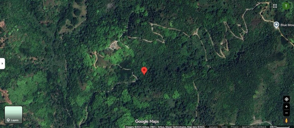
🗺️ Property Map

Interactive map showing the exact property boundaries and location

Loading map...

Interactive property boundary map located in Lawrence Tavern, St. Andrew parish, Jamaica.

Tax & Investment Information

What you get when you unlock this parcel

Boundary maps, lot size, scheme details, AI valuation insight and OFMOP local context are already free on this page. The unlock adds the verified Tax & Ownership record:

  • 👤 Owner of record — name and registered address from TAJ
  • 💰 Annual property tax — current amount due + paid/unpaid status from TAJ
  • 📊 Assessed value — the unimproved value TAJ uses to compute the tax
  • 📜 Payment history — recent tax-payment entries on the parcel

Tax records sourced from Tax Administration Jamaica (TAJ). Land boundaries and lot dimensions come from the National Land Agency (NLA) and are already on this page.

One-time per parcel, or unlimited with Premium. Receipts in your customer portal.

AI-powered estimation based on comprehensive analysis of location, demographics, infrastructure, and market factors

Estimated Value (JMD)
JMD 31,831,678
Estimated Value (USD)
USD 212,211
Confidence Score
80%
Market Multiplier
0.97x
📊 Value Range Analysis
JMD Range:
JMD 25,465,342 - JMD 38,198,014
📊 Analysis Details
Summary: AI analysis indicates a land value of JMD 31,831,678 based on 80% confidence analysis of population density, building count, facilities, and environmental factors.
Key Factors: Population density: 1894 people • Building count: 1 • Nearby facilities: 0 • Environmental score: 0.0% • Economic score: 0.0%
Tax Status: Not Available
Legal: Property appears to be legally registered
Improvements: Property has existing structures

In and Around

Buildings, public facilities, attractions and transport identified at or near this parcel — sourced from OpenStreetMap and our analysis pipeline.

Transport

4
  • ResidentialNearby23 m
  • Burnt Shop RoadNearby310 mUnclassified
  • Crookers Hill RoadNearby310 mResidential
  • TrackNearby865 m

Property record

ID: 671636

This 4,047 m² parcel measures roughly 65 m wide by 101 m deep, with a 7-vertex boundary.

St. Andrew is a southeastern parish — suburban and residential in character, surrounding the capital city.

Surrey County is the eastern third of Jamaica, anchored by Kingston and the Blue Mountains.

Located 3.1 km from the centre of Lawrence Tavern and 11.4 km from Half Way Tree, the parish capital.

OpenStreetMap places this parcel within Crookers Hill Road, Crookers Hill, Saint Andrew, Surrey County, Jamaica. OSM classifies the surrounding area as residential.

Satellite imagery shows one structure within the parcel boundary, indicating an at-least-partially developed lot.

Vegetation cover reads as high green (NDVI 0.70).

Nearest highway: Burnt Shop Road, approximately 310 m from the parcel boundary.

OFMOP records 18 indexed public facilities; 11 transit routes; garbage collected by MPM on Saturday for this district.

Indicative AI valuation: JMD 31,831,678 ≈ USD 212,211 (80% confidence).

🏠 Nearby on the market

🏠 Real Estate Investment Opportunities

Discover properties for sale and rent in this prime location. Perfect for investors looking for opportunities in this growing area.

💰Properties for Sale

2 Available
PETERS RETREAT, CAVALIERS
FOR SALE
1 / 10

PETERS RETREAT, CAVALIERS

JMD $51,240,000

0
📏762,299.97 sq ft

👨‍💼Travis Ffrench

🏢EDGE REALTY JAMAICA LTD

BURNT SHOP RD
FOR SALE
1 / 9

BURNT SHOP RD

JMD $14,000,000

🛏️2 beds
🚿1 baths
📏419,793.01 sq ft
🏢1,493.00 sq ft

👨‍💼Steven Watson

🏢CENTURY 21 HEAVE HO PROPERTIES

🏠Properties for Rent

0 Available
🏠

No Properties for Rent

Currently no properties available for rent in this area.

📊 Investment Summary

2
Properties for Sale
0
Properties for Rent
2
Total Opportunities

Checking access...

About Lawrence Tavern

Community data powered by OFMOP — Out of Many, One People.

Facilities serving Lawrence Tavern

  • Edna Manley College of the Visual & Performing ArtsTertiary
  • Excelsior Community CollegeTertiary
  • Golden Valley Primary and InfantSchool
  • King Weston Primary and InfantSchool
  • LAWRENCE TAVERNPost Office
  • Lawrence Tavern Primary and InfantSchool
  • Oberlin HighSchool
  • Paisley PrimarySchool
All facilities in Lawrence Tavern on OFMOP

Transit routes through Lawrence Tavern

11 routes serve this district.

  • Grande Hole - Half Way TreeRoute 52BJutc
  • Mount Charles - Hagley GapRoute MOUTaxi Rank
  • Glengoffe - Lawrence TavernRoute GLETaxi Rank
  • Mount Industry - Lawrence TavernRoute MOUTaxi Rank
  • Essex Hall - Stony HillRoute ESSTaxi Rank
Transit details for Lawrence Tavern on OFMOP

Garbage collection

Residential garbage in Lawrence Tavern is collected by MPM on Saturday. Waste is hauled to riverton disposal site.

Garbage schedule for Lawrence Tavern on OFMOP

Nearby fuel stations

  • IndependentLOT #1 HARBOUR HEAD, NORMAN MANLEY P.A., KINGSTON
    ULSD · J$228
  • Johnsons Petroleum34 BEECHWOOD AVENUE, KINGSTON 5
    E10 87 · J$166.6ULSD · J$222.9
  • Total Jamaica250 SPANISH TOWN ROAD, KINGSTON
    E10 87 · J$183.7ULSD · J$215.8
Fuel stations around Lawrence Tavern on OFMOP

Powered by Jurifi · Jamaica legal Q&A

Have a legal question about this property? Tap a prompt to open Jurifi with the parcel context already filled in.

AI assistance only. Not legal advice. Consult a Jamaican attorney before acting on any output.

Nearby Properties in Lawrence Tavern